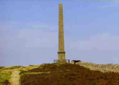
We start off from the Town Hall via the Kirk Wynd and Mount Hooley if we wish. The other alternative is to break our Tibby Lugs walk at its entrance, where we have elected to continue on up the incline until our path is blocked by the large cattle gate, we climb over the gate and discover that our feet are standing on a well-trodden path, and if we glance to the right, we will observe Langholm's nine-hole golf course. Follow the track which is going towards a power pylon, and to the side of this electricity tower we will espy a green painted wooden bench to the side of it which overlooks Whita Well, that is a natural spring from which flows cool, sweet fresh water to quench the thirst. Now, we simply follow the path up the breast of the hillside watching the Monument coming ever-larger as we approach it until finally, when only a few yards away, the full impact hits us. The 100 foot high obelisk has four faces and was built in 1834, using stone from the town's quarries over the back of Whita hill, by members of the Graham family from Netherby Estate of Longtown, and was dedicated to Sir John Malcolm, soldier, diplomat and scholar, one of the famous Malcolm brothers, known as the Four Knights of Eskdale. It has come to my notice recently that the track from the Newcastleton road to the Monument has been levelled out sufficiently for vehicles to travel on, and apparently there are lay-by type pull-in sections at various positions along the track. The only problem is having to gain access via a gate that is chained and padlocked, I have still to ascertain where I could acquire a key for the lock.
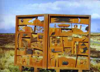
On our descent, I'm sure that you couldn't help noticing a peculiar, but intriguing looking structure that resembles an open book with various shapes and forms cut out from it. This is the spectacular and somewhat controversial memorial that Jake Harvey created in honour of the Langholm born bard, Hugh MacDiarmid, who was born in 1892, and to which a celebratory luncheon interspersed with poetic recitations was arranged for 13th September, 1992 to celebrate the centenary of his birth.
There were many fine Scottish poets and speakers in attendance of whom I had the great honour of meeting because I was a member of the organising committee. There was Tom Fleming, Hamish Henderson, Norman McCaig, who was a good friend of MacDiarmid, Sorley McLean and Edwin Morgan all reciting various poems of MacDiarmid's works, the most famous being A Drunk man Looks at the Thistle
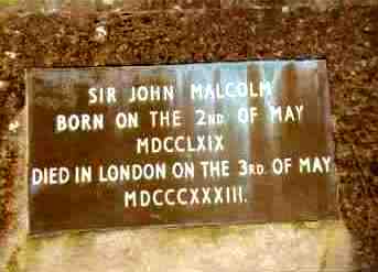
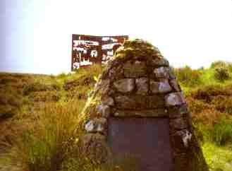
A few yards from the end of the track stands a small cairn that bears the inscription:
When we have read and mulled over the inscribed words, we take to the Langholm to Newcastleton road and turn left down the hill, follow the sign to the memorial, climb up the slope towards it, and gaze at it at close quarters analising the cut out shapes and guessing what these could be. Back onto the road and if we cast our eyes to the right we will take in the wonderful panoramic view of the Ewes valley where the A7 trunk road cuts into the hills in the distance. About two hundred yards on down the incline is the part of the road called 'Collin's Turn', it is unmarked, but any Langholmite who is a Common Riding enthusiast will happily explain that the Hound Trail that precedes the annual Common Riding is begun and finished only a little way over and down the banking.
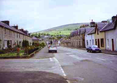
We take our first steps from the Town Hall and head northwards up the High Street following the road past the de-consecrated Erskine Church, we cross the road in front of a short row of houses by name of Victoria Place, we continue on past the former Greenbank Eventide Home, past the former Townhead tollhouse on our left, a few yards further and we will observe the Tourist Information Centre where all manner of literature on Dumfries and Galloway locations, more particularly concerning Annandale and Eskdale can be obtained. Ahead and to our left we will observe the Kilngreen daytime car park with the Ewes Bridge, known locally as the 'Sawmill Brig' beyond it.
We head in the direction of the bridge and progress over it. During our short trip across the bridge, when we look diagonally to the left we will observe the remains of Langholm Castle between the trees, and many years ago in the 1700's a little distance upriver there existed a pool that was used by the authorities to punish criminals by drowning named the 'Grieve'.
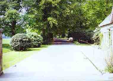
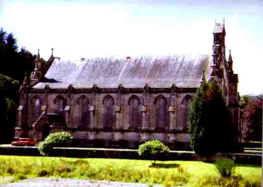
Continue on down the road and we will pass between two stone gate pillars that mark the entrance to the Lodge grounds, then walk on for only fifty yards more, and we will encounter a small church to our right that is screened on one side by a row of fir trees. This is the English Episcopalian church and was originally the estate chapel for their Graces, the Duke and Duchess of Buccleuch, and possibly friends who were staying over at the weekend many years ago. The church was built in 1883 and is undoubtably the smallest house of prayer in the confines of the town. It was closed for good in 1998, deconsecrated and turned into the Armstrong Trust Museum that houses all manner of Armstrong souvenirs and publications.
Starting off again, we continue taking in the marvellous sight of the variety of trees, shrubs and flowers, we continue on until the first gentle right-hand bend in the road. Looking diagonally to our left along a short road flanked by rhododendron bushes we are able to see a large grassed area, this was the site of the original lodge mansion house that was built in 1786. It had to be demolished owing to a serious dry rot infestation in 1789. Should we continue and opt for the right side of a fork in the road, we will eventually come to the old North Lodge that was formerly used for accommodation for guests of the Duke or Duchess who were staying over during pheasant shoots. It is used now for estate workers and their families as their accommodation. Carry on and turn down the narrow road to the left and follow it round, you are now in the heart of the 'camp', so named after the whole of the area was turned into designated accommodation for the Polish allied army after the second world war was over. The original concrete floors on which the arch rooved sheds stood on can still be seen quite clearly among the pheasant pens scattered about the field. We walk on past a small cottage that stands behind the old military garage shed that used to have two military lorries parked inside for many years, then proceed for a further fifty yards when we realise that we have walked the full circle and arrived back at the fork in the road.
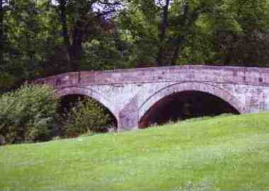
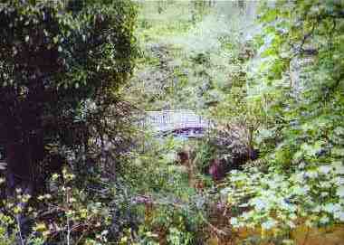
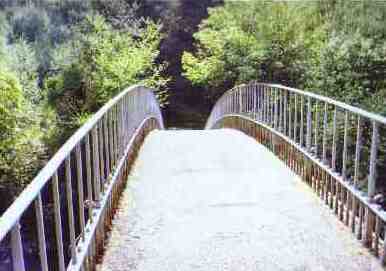
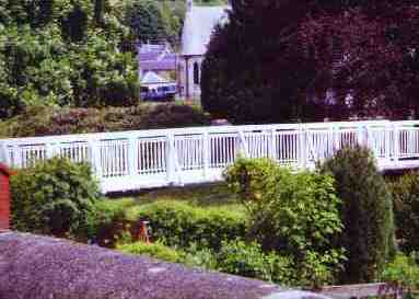
At this point we turn to our right and go past an 'L' block of terraced houses inhabited by estate workers and their families. We continue onward down the track beyond the terraced houses and turn left at the bottom, then down a small narrow incline and the Duchess Bridge will come into view on our right. This old footbridge was erected in 1813 and was reputed to be the first cast iron bridge in Scotland, and was built and named after the Duchess of Buccleuch of that time.
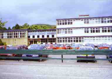
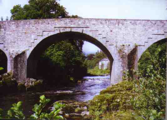
The bridge spans the river Esk, so take this opportunity to look over the side and perhaps you will catch sight of a sea trout or young salmon making its way slowly up the river. Once we have crossed over the bridge, we follow the riverside path until its conclusion at the end of the wood on our right where we enter the school playing field and walk along the path that skirts it. We come to the end of the path where it meets the Langholm to Eskdalemuir road. Across the road is the Langholm Primary School, formerly Langholm Academy. The main building was constructed in 1854, with an additional higher wing being added on in 1894. We turn left and carry on down Thomas Telford Road named after the famous locally born engineer who assisted in the Langholm Bridge's construction when he was an apprentice mason.
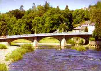

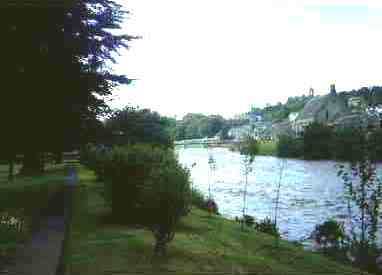
His apprentice mason's mark can be seen on the keystone of the central arch. As we cross over the bridge, we will observe the 'meeting of the waters' to our left where the Ewes river runs into the Esk river, and to our right the Suspension Bridge as it is known locally, with the Old Parish Church acting as a scenic backdrop. We turn right after crossing the bridge and keep going for 100 yards along the High Street to where a three-storey building is situated on the left side of the road, look above the entrance door to the Royal Bank of Scotland and we will observe a man's features along with four children's faces carved out of stone and included in the door arch's ornamentation, the faces belong to a Mr Anderson and his four children, he was a former banker. This fine old building was built in 1867 when a banker was obviously held in high esteem. Another two hundred yards further and we will have arrived back at the Town Hall. Since the time of writing, all sculptured heads have been removed.
If we stand on the step of the Town Hall facing northwards, we will observe a street opening diagonally left from us, head for that opening and follow the road round to the left and enter Charles Street, then carry on down the slight incline until we come to the Boatford Suspension Bridge, so called because there was once a ford across the Esk at that point. The bridge was actually completed in the 1800's and people had piled onto it to have their photograph taken at the official opening, when due to overloading and an intolerable strain was placed on the bridge's supports which resulted in a weak area that inevitably broke and the bridge and its occupants collapsed into the river. Luckily the river wasn't in spate. As we cross the bridge we will experience the splendour of the Old Parish Church and beyond it the Buccleuch Park with its black angel war memorial. The church was built in 1843 and stands in its own grounds. A stone bridge has to be crossed which straddles the Wauchope river before it merges into the Esk. Once we have crossed the river via the Boatford suspension or swing bridge we exit it into Caroline Street, cross the road onto the pavement on the right side of the street and continue on for a 100 yards or so and we will come upon a small footbridge on the left side of the street straddles the river and allows us entry into the park.
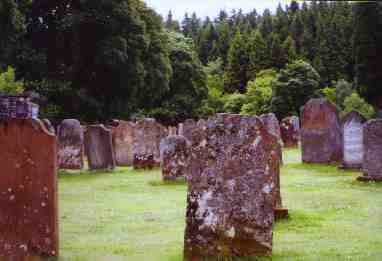
We cross the bridge and turn to our right and carry on along the tarmac path which turns to the left and then goes past the children's swings. Stop at the steps immediately before the swings, climb them and head for the pathway and steps in the wood behind and follow them to their conclusion at the top. When we have reached the top turn to the right, walk about twenty paces and look to your right for a splendid panoramic view of the town and its hillsides. Continue along the narrow footpath we will observe that the route ahead is full of twists and turns. Towards the end of the footpath we will be very aware of the sheer drop into the river, and if we cast our eyes in a slightly upward direcion across the river, we will observe the outline of tombstones against the sky. This is the old Wauchope cemetery, the subject of a sonnet by William Wordsworth a long, long time ago.
We continue to the end of the path and observe the Auld Stane Brig to our right, clamber down the rough path onto the Langholm to Lockerbie road. We turn right and head for Langholm, first we cross the bridge and carry on up a short but steep incline which takes us past the locked double gates of Wauchope cemetery. Immediately past the cemetery we come to where the former Old Parish Church Manse stands that was built in the 16th century and was the birthplace of William Julius Mickle famed author and poet, one of his more well known works being, "There's Nae Luck Aboot The Hoose". The manse was sold by the church and is now privately owned. It was originally built on the site of Wauchope Castle which was a 13th century building, previous to that it was purported to have been a timber-built Norman stronghold. We progress down the long hill and turn the sharp left-and corner and then the Auld Caul comes into view over the wall to our right, this was used to raise the level of water that was used by the local tweed mills, by now we can see the outskirts of Langholm a few yards ahead. We continue on and enter Caroline Street, this time from the west side, and we will notice the few single storey cottages of the town on our right as we pass them, then we pass the Park Bridge and the Auld Parish Kirk once more.
The church is a magnificent example of its period, standing proudly within its own grounds. At this point we'll take a small but interesting detour by turning to our right and pass through the gates that are permanently open, over the wee bridge and up to the few stone steps at the church's entrance which we climb, and enter the vestibule. The style of the building is very much old Gothic, with its interior furnished predominantly in elm wood that looks as new as the day it was installed. The south-facing stained glass windows contain three main elongated arched windows depicting various scenes from Christ's life. The church has survived through monies raised by public subscription over the years and is a clear example to the loving care and regular maintenance that is has been afforded. After our tour of the church, we make our way back over the stone bridge and turn to the right then over the Boatford suspension bridge, and why not take a different route by turning to the right, then we will be on the way along the riverside, We turn to the left at the first tarmac road end and we will pass the Royal British Legion Scotland's Social Club building on our left, and I am proud to say that I was the secretary of the branch and the social club for three years and served on the Dumfries and Galloway Area Committee and was also a serving member of the National Council which met at HQ in Edinburgh. Continue in a straight line along the road called Laird's Entry that has a high stone boundary wall between the Thomas Hope Hospital and the roadway. Up the short narrow incline and into the Market Square, and the Town Hall is just to our right around the corner.
| Roon' Hoose | Jenny Noble's Gill | Auld Distillery | Easton's Walk |
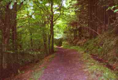
Starting off from the Town Hall, we head off in a southerly direction to the bottom of the High Street as far as the once Townfoot Tollhouse that is a small stone-built cottage jutting out and is preceded by a high wall on the right side of the road. As the road turns to the right, we will observe a narrow road on the left that breaks away from the main one that leads up a long gradual incline. We take this road and hold to the right side of the fork ahead that brings us into a narrower road yet that has a high stone wall to our right. We keep going until the road changes from tarmacadam to a stony track and a wide wooden gate appears to impede our access. We will observe, however that there is a small swing gate to the left side of the large one, which we go through and then begin to climb the narrow stony track that is flanked by gorse bushes, clumps of heather and all manner of wild flora. The skylark can be heard around this point and onwards, perhaps an odd cry of a lapwing may be heard sometimes as it flies over the hillsides that are carpeted with fern and bracken. We now take time out to look to our right and behind us to experience the town and its surrounding hills from a fantastic vantage point.
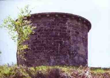
We are able to see the Esk clearly as it makes its way south flowing under the Skipper's Bridge as it makes its way to the Solway Firth. Between the river and ourselves we observe a narrow flat grassy pathway, this is the only sign in and around the town that a once busy spur from the main Edinburgh to Carlisle railway ever existed. The passenger train service was closed on the 13th June 1964 as the cairn in the Townfoot next to the northernmost car parking area testifies. After about two hundred yards up the track we will begin to see the Roon' Hoose between the trees ahead. As we approach nearer to the structure, we have a choice to make. Do we carry on straight up the steep grassy mound that has tree roots threading their way through the ground surface, or do we keep to the path and circumvent the wee building for twenty yards or so, until the ground levels off, and then simply make a direct route to it via the level grassed area? Apparently, the building was a round summerhouse with an open side that had a conical roof that was vandalised so badly, the walls were built up and filled in to prevent it ever happening again, and it hasn't.
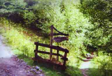
After an ample intake of fresh air and our legs well rested after a twenty minute pause that gave us the opportunity to take in the beauty of the countryside in all directions, we head for the path to continue on in the same direction. It's not long before a wooden sign directing us to Jenny Noble's Gill is encountered at the side of a fern-lined path. We follow the path up to the wooden steps that we climb up and over onto the former railway track route, then climb the steps over the wire fence on the other side of the track. We are now at the top of a fairly steep incline at the top of a wood, we climb down the sloping ground on to the Tarras road. We then turn to the right in the general direction of Langholm and follow the road with trees creating an archway along the length of it.
The views of the river and its bankings are so picturesque from our position, especially when we draw closer to the Skipper's Bridge and we experience the rushing waters of the Esk breaking up on the rocks and swiftly flowing under it's arches.
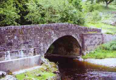
The Skipper's Bridge is extremely old, having been constructed in 1690, its name apparently came from a retired ship's captain who ferried people across the Esk in his rowing boat, whether he charged for his service or not is not known.
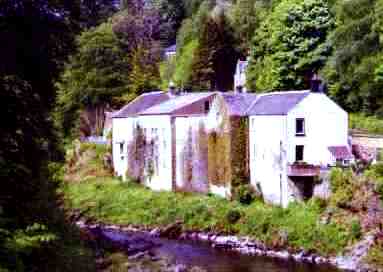
We have reached the bridge, we now turn left onto it and after pausing for a few minutes to look downriver where we will see fishermen angling for sea trout or salmon that the Esk is famed for, then looking upriver we will observe a large white coloured building not that far away that has a waterwheel attached to its base, now no longer used. This is where Arthur Tolson Snr. and Jnr. have made their homes in two different parts of the building, with Arthur Jnr. operating a repair garage for cars and light vans etc. The building has been host to a paper mill in the late 18th century, and a whisky distillery later in the 19th century, and there are a few bottles in the town being kept for posterity. We proceed to the end of it where we can see dead ahead the steep winding cemetery road with its entrance forking away from the next left-hand bend. We are not going that way, anyway, we are going to make a sharp right at the end of the bridge, past the Murtholm farm fields, then the farmhouse with its cottage immediately past it, round a right-hander, then a left and back onto a fairly good farm road.
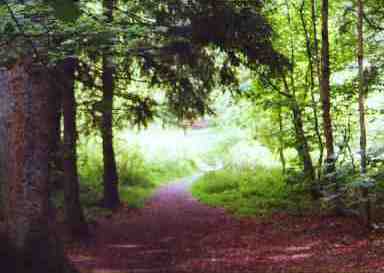
We continue along until we reach the wood ahead and take the lower of the two tracks. The other track incidentally takes us to the wonderful viewing point at the start of Gaskell's Walk opposite the 'Stubholm'. We will progress along the lower pathway that is known locally as 'Easton's Walk' and find that we are climbing to the top of the river's banking, on a natural pathway that runs parallel with the river approximately four feet wide and a fair height up above the water's level. From here we will experience the habits of the riverside birdlife if we look very closely. Above the town's rooftops in the east we will observe the Monument standing on the crest of Whita Hill once more.
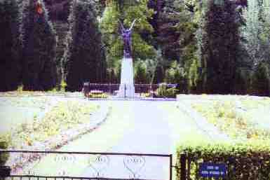
Carry on a little further and we will immediately recognise the Auld Parish Kirk, with the suspension bridge to its right. We are now at the end of our path and in the grounds of the Buccleuch Park, past the putting green, the park is laid out with planted flower beds that are a riot of colour during the summer months. In the centre of the park is the figure of a sculptured Black Angel that is the Royal British Legion Scotland's Langholm branch war memorial. She is standing upon a tall marble plinth with four facets that have the names of local servicemen who laid down their lives in defence of their country over two world wars.
Head for the exit at the far side of the park, then cross the small footbridge that straddles the Wauchope river and you will be stepping into Caroline Street, turn to the right and carry on along the pavement on the other side down to the suspension bridge. Cross the bridge and go straight up the road beyond it, when the top of the road has been reached, turn to your right and you will encounter the Market Place and the Town Hall.
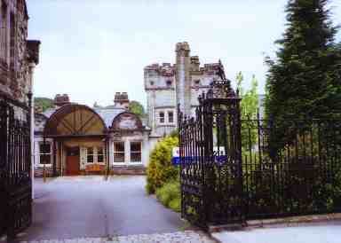
At this point I'm sure that you have noticed the grey stone building to our right, this is the Thomas Hope hospital that was financed by him, and then subsequently donated it to the townspeople and officially opened in 1898, it was built by a certain Thomas Telfer, not to be confused with our famous Thomas Telford, the world-renowned civil engineer.
Inside the hospital in the front lobby there is a stone slab mounted in a frame fixed to the wall that has the inscription as follows: