Introduction
Langholm is sited at the confluence of the Rivers Esk and Ewes. The 'new town' of Langholm was founded by the Duke of Buccleuch in the 17th century. The town became a regional wool centre with several mills in production from the mid 19th century onwards. Its industries have also included cotton manufacture and distilling, including many family-run enterprises such as sword-makers, candle-moulders, tailor's, milliner's, and others.
There are few towns in the district such as Langholm that can boast of so many different walkways. Our well-trodden paths not only give a variety of viewpoints, but each possesses its own unique and particular charm. They have all been stepped out by locals over many years, but not all the walks that the town has to offer have been experienced by visitors. I've tried to describe the walks as I remember them when I was younger, so forgive me if my description does not match-up today's physical appearance.
But don't take my word for it, try walking them yourself, you'll find them most interesting and rewarding, and best of all, they are free.
BITS O' WALKS
Alang throw th' Langfa' whun wid pigeons teek fleiyt
Roon' Gaskell's Walk joost afoor fa' o' neiyt
Throw Tibby Lugs loanin' an' oot tae the Lamb Hill
Picters iver in ma maiynd, o' sae breiyt still.
Alang be Jenny Noobels an' doon wids sae steep
Tae Doag Island whair man's best freen's a' sleep
Back oan tae the road taeward Tarras Brig an' by
Yon muckle viaduc', the trains yaised, sae high.
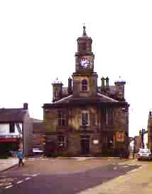
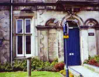
We start our tour and take the Town Hall as our starting point
Select thumbnail image to display larger picture
This ancient and solid edifice formerly known as the Town House has been in existence for many years having been built between 1811 and 1812. As in all town halls before regionalisation, it was the meeting place of the town council for many years, and prior to that, as they were known, the Burgesses, who were the town's tradesmen.
The building was originally built as a place of imprisonment and was used by the local authorities as such for a number of years. Apart from housing petty criminals until they were moved on to Dumfries Prison, the right-hand ground section was altered into a haberdasher store in years long since past.
The adjoining southermost part of the building is the place that young Christopher Murray Grieve, (1892-1978) the world renowned poet, pen name Hugh MacDiarmid, who spent his days as a lad in the premises of the town post office, his father being the local postman for many years.
Above him on the next floor was the Thomas Telford Library, built between 1875 and 1878, it was so named because the gentleman generously donated £1,000 towards its cost, which was a large amount of money in those days. The library was used to its full capacity as a lending and reference library until the new Council-run library was opened in a part of the former Langholm Primary School premises that are situated just off Charles Street, and is still operating as the town's lending library up to present.
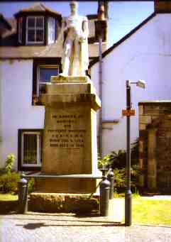
The Marble Man
Select thumbnail image to display larger picture
If we continue along the side of the building that fronts on to the High Street, for several more yards further, a white marble statue comes into view, this is a sculpture dedicated to Admiral Sir Pulteney Malcolm, naval commander at St. Helena during Napoleon Bonaparte's exile after the Battle of Waterloo who lived from 1768 to 1833 as the inscription on the plinth supporting his statue will verify. A striking figure in full dress uniform complete with dress sword, looks out over towards the extinct volcano Warblaw hill, now a scene of peaceful grazing pastures for sheep and cattle.
The statue was formerly positioned only a few yards in front of the Town Hall and was subsequently moved to its current location in 1886.
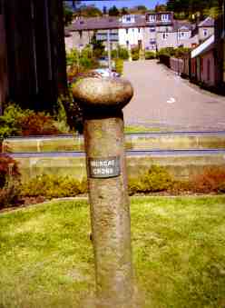
In the same grounds you will observe the old Mercat Cross (c. early 17th century) in the north-west corner which was originally sited in the middle of the Market Place, it was later moved to the grounds of the Greenbank Eventide Home which overlooks the confluence of the Ewes and Esk rivers and then returned to its present site.
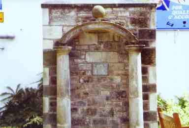
Thomas Telford Reference Library
Select thumbnail image to display larger picture
Casting our eyes in a southerly direction we will observe what resembles an arched stone doorway supported on two stone pillars. There is a stone plaque which bears the inscription detailing Thomas Telford's date of birth and death. The archway was constructed by him during his apprenticeship years. Thomas Telford was born in Bentpath in the Westerkirk parish some six miles north of Langholm. Glancing behind us and our eyes will meet with the set of double doors, this is the entrance to the Thomas Telford reference library, it is accessed via the corridor inside, then turning through a door on the right at the end of it, up two short flights of stairs and finally arrive outside the half-glazed door and the library beyond. It is only an eighth of the area of the original library but does contain the best of the books that once sat on its shelves.
Select thumbnail image to display larger picture
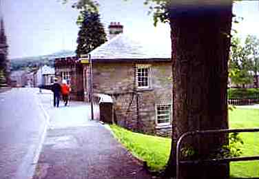
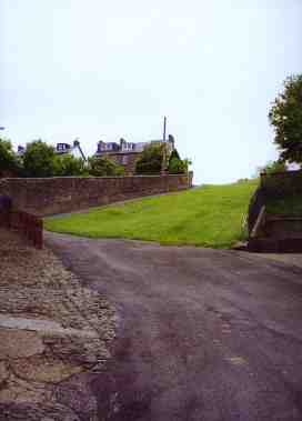
Starting off from the Town Hall and look northwards and we will observe a street to our right that is named the Kirk Wynd. When we starting walking up the tarmac brae we will observe directly ahead about 120 yards ahead, the former EU Church, the initials representing Evangelical Union, when we are approximately 20 yards from the church building, we observe a road to our left that is part of the original old drove road that was also the only road through Langholm a long, long time ago. At this point we have a decision to make. Do we continue along the drove road or go by the more strenuous route up the grassy slope and on to Mount Hooley, which though much shorter a route, is extremely steep and only for the strong of heart. There is a metal handrail afixed to the old kirkyard boundary wall to assist our ascent.
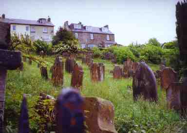
Langholm's Auld Kirkyard
Select thumbnail image to display larger picture
Let us assume we elect to take the former route rather than the latter, then we turn left into the old drove road used by tens of thousands of sheep, cattle, dogs, men and women during those days long since past when Langholm was regarded as one of the busiest market towns for the sale and purchase of stock animals for many miles on both sides of the border. We continue along for fifty yards and where the road bears to the right, a short, steep incine is to be climbed. During our ascent, if we look to our left, we will see that the wall in fact is the remains of the fronts of old cottages. Onwards until the road begins to level out. If we glance round to our right we will see that a narrow road sharply inclines away from us and runs past two sets of terraced houses before coming to its end at the locked double gates where Langholm's old graveyard lies beyond. Herein, on our right stands the ruins of a former parish church after it was gutted by fire a long time ago. The church bell was removed from the bell tower and placed inside the vestibule of the current Old Parish Kirk that stands on the former Eldingholm. The first recorded parish church was built in 1703, then the next one was built in 1779, and finally in 1797, all on the same site in the graveyard.
Select thumbnail image to display larger picture
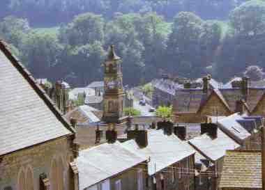
Back down from the graveyard on to the old Drove Road and we will pass two houses set back off the road that are fronted by low rustic wrought iron painted railings. Turn right at the end of the railings, take a deep breath and begin to climb the curving road ahead that eventually levels off in Arkinholm Terrace. Again reference can be made to Hugh MacDiarmid once more because he lived part of his life in number 17 it is recorded. Another fifty yards or so and we approach Mount Hooley's crest, and if we look to our right we obtain a magnificent view of the town and surrounding hills, and also realise that we are only two hundred yards away from the High Street, so now it is evident that although the direct route is much more energetic, it would have cut our progress time by 20 minutes. As we will observe, there is a bench placed at this location to aid recovery and to give us a chance to catch our breath. Rested and refreshed, if we about-turn we will observe the Malcolm Monument standing proud and erect on the crest of Whita Hill, and we can see our route dead ahead...