The military roads were about eight hundred miles in extent and maintained at the public expense but they were laid out for purposes of military occupation rather than for the convenience of the districts which they traversed. Hence they were comparatively little used and the Highlanders in passing from one place to another for the most part continued to travel by the old cattle tracks along the mountains. But the population were as yet so poor and so spiritless and industry was in so backward a state all over the Highlands that the want of more convenient communications was scarcely felt.
Though there was plenty of good timber in certain districts the bark was the only part that could be sent to market on the backs of ponies while the timber itself was left to rot upon the ground. Agriculture was in a surprisingly backward state. In the remoter districts only a little oats or barley was grown the chief part of which was required for the sustenance of the cattle during winter. The Rev. Mr Macdougall minister of the parishes of Lochgoilhead and Kilmorich in Argyleshire described the people of that part of the country about the year 1760 as miserable beyond description. He says "Indolence was almost the only comfort they enjoyed. There was scarcely any variety of wretchedness with which they were not obliged to struggle or rather to which they were not obliged to submit. They often felt what it was to want food.... To such an extremity were they frequently reduced that they were obliged to bleed their cattle in order to subsist some time on the blood(boiled) and even the inhabitants of the glens and valleys repaired in crowds to the shore at the distance of three or four miles to pick up the scanty provision which the shellfish afforded them."
The country lying to the west of the Great Glen was absolutely without a road of any kind. The only district through which travellers passed was that penetrated by the great Highland road by Badenoch between Perth and Inverness, and for a considerable time after the suppression of the rebellion of 1745 it was infested by gangs of desperate robbers. So unsafe was the route across the Grampians that persons who had occasion to travel it usually made their wills before setting out. Garrons or little Highland ponies were then used by the gentry as well as the peasantry. Inns were few and bad, and even when postchaises were introduced at Inverness the expense of hiring one was thought of for weeks perhaps months and arrangements were usually made for sharing it among as many individuals as it would contain.
If the harness and springs of the vehicle held together travellers thought themselves fortunate in reaching Edinburgh jaded and weary but safe in purse and limb on the eighth day after leaving Inverness. Very few persons then travelled into the Highlands on foot though Bewick the father of wood-engraving made such a journey round Loch Lomond in 1775. He relates that his appearance excited the greatest interest at the Highland huts in which he lodged the women curiously examining him from head to foot having never seen an Englishman before. The strange part of his story is that he set out upon his journey from Cherryburn near Newcastle with only three guineas sewed in his waistband and when he reached home he had still a few shillings left in his pocket!
In 1802 Telford was called upon by the Government to make a survey of Scotland and report as to the measures which were necessary for the improvement of the roads and bridges of that part of the kingdom and also on the means of promoting the fisheries on the east and west coasts with the object of better opening up the country and preventing further extensive emigration. Previous to this time he had been employed by the British Fisheries Society of which his friend Sir William Pulteney was Governor to inspect the harbours at their several stations and to devise a plan for the establishment of a fishery on the coast of Caithness. He accordingly made an extensive tour of Scotland examining among other harbours that of Annan from which he proceeded northward by Aberdeen to Wick and Thurso returning to Shrewsbury by Edinburgh and Dumfries. He accumulated a large mass of data for his report which was sent in to the Fishery Society with charts and plans in the course of the following year.
In July 1802 he was requested by the Lords of the Treasury most probably in consequence of the preceding report to make a further survey of the interior of the Highlands the result of which he communicated in his report presented to Parliament in the following year. Although full of important local business "kept running" as he says "from town to country and from country to town never when awake and perhaps not always when asleep have my Scotch surveys been absent from my mind." He had worked very hard at his report and hoped that it might be productive of some good.
The report was duly presented, printed and approved, and it formed the starting point of a system of legislation with reference to the Highlands which extended over many years and had the effect of completely opening up that romantic but rugged district of country and extending to its inhabitants the advantages of improved intercourse with the other parts of the kingdom. Telford pointed out that the military roads were altogether inadequate to the requirements of the population and that the use of them was in many places very much circumscribed by the want of bridges over some of the principal rivers. For instance the route from Edinburgh to Inverness through the Central Highlands was seriously interrupted at Dunkeld where the Tay is broad and deep and not always easy to be crossed by means of a boat. The route to the same place by the east coast was in like manner broken at Fochabers where the rapid Spey could only be crossed by a dangerous ferry.
The difficulties encountered by gentlemen of the Bar in travelling the north circuit about this time are well described by Lord Cockburn in his 'Memorials.' "Those who are born to modem travelling can scarcely be made to understand how the previous age got on. The state of the roads may be judged of from two or three facts. There was no bridge over the Tay at Dunkeld or over the Spey at Fochabers or over the Findhorn at Forres. Nothing but wretched pierless ferries let to poor cottars who rowed or hauled or pushed a crazy boat across or more commonly got their wives to do it. There was no mail-coach north of Aberdeen till I think after the battle of Waterloo. What it must have been a few years before my time may be judged of from Bozzy's 'Letter to Lord Braxfield' published in 1780.
He thinks that besides a carriage and his own carriage horses every judge ought to have his sumpter horse and ought not to travel faster than the waggon which carried the baggage of the circuit. I understood from Hope that after 1784 when he came to the Bar he and Braxfield rode a whole north circuit and that from the Findhorn being in a flood they were obliged to go up its banks for about twenty-eight miles to the bridge of Dulsie before they could cross. I myself rode circuits when I was Advocate Depute between 1807 and 1810. The fashion of every Depute carrying his own shell on his back in the form of his own carriage is a piece of very modern antiquity." North of Inverness matters were if possible still worse. There was no bridge over the Beauly or the Conan. The drovers coming south swam the rivers with their cattle. There being no roads there was little use for carts. In the whole county of Caithness there was scarcely a farmer who owned a wheel cart. Burdens were conveyed usually on the backs of ponies but quite as often on the backs of women.
The interior of the county of Sutherland being almost inaccessible the only track lay along the shore among rocks and sand and was covered by the sea at every tide. "The people lay scattered in inaccessible straths and spots among the mountains where they lived in family with their pigs and kyloes (cattle) in turf cabins of the most miserable description, they spoke only Gaelic and spent the whole of their time in indolence and sloth. Thus they had gone on from father to son with little change except what the introduction of illicit distillation had wrought and making little or no export from the country beyond the few lean kyloes which paid the rent and produced wherewithal to pay for the oatmeal imported." Telford's first recommendation was that a bridge should be thrown across the Tay at Dunkeld to connect the improved lines of road proposed to be made on each side of the river.
He regarded this measure as of the first importance to the Central Highlands and as the Duke of Athol was willing to pay one half of the cost of the erection if the Government would defray the other, the bridge to be free of toll after a certain periodit appeared to the engineer that this was a reasonable and just mode of providing for the contingency. In the next place he recommended a bridge over the Spey which drained a great extent of mountainous country and being liable to sudden inundations was very dangerous to cross. Yet this ferry formed the only link of communication between the whole of the northern counties. The site pointed out for the proposed bridge was adjacent to the town of Fochabers and here also the Duke of Gordon and other county gentlemen were willing to provide one half of the means for its erection.
Telford further described in detail the roads necessary to be constructed in the north and west Highlands with the object of opening up the western parts of the counties of Inverness and Ross and affording a ready communication from the Clyde to the fishing lochs in the neighbourhood of the Isle of Skye. As to the means of executing these improvements he suggested that Government would be justified in dealing with the Highland roads and bridges as exceptional and extraordinary works and extending the public aid towards carrying them into effect as but for such assistance the country must remain perhaps for ages to come imperfectly opened up. His report further embraced certain improvements in the harbours of Aberdeen and Wick and a description of the country through which the proposed line of the Caledonian Canal would necessarily pass a canal which had long been the subject of inquiry but had not as yet emerged from a state of mere speculation.
The new roads bridges and other improvements suggested by the engineer excited much interest in the north. The Highland Society voted him their thanks by acclamation the counties of Inverness and Ross followed and he had letters of thanks and congratulation from many of the Highland chiefs "If they will persevere with anything like their present zeal they will have the satisfaction of greatly improving a country that has been too long neglected. Things are greatly changed now in the Highlands. The lairds have transferred their affections from their people to flocks of sheep and the people have lost their veneration for the lairds. It seems to be the natural progress of society but it is not an altogether satisfactory change. There were some fine features in the former patriarchal state of society but now clanship is gone and chiefs and people are hastening into the opposite extreme. This seems to me to be quite wrong."
In the same year Telford was elected a member of the Royal Society of Edinburgh on which occasion he was proposed and supported by three professors so that the former Edinburgh mason was rising in the world and receiving due honour in his own country. The effect of his report was such that in the session of 1803 a Parliamentary Commission was appointed under whose direction a series of practical improvements was commenced which issued in the construction of not less than 920 additional miles of roads and bridges throughout the Highlands one half of the cost of which was defrayed by the Government and the other half by local assessment. But in addition to these main lines of communication numberless county roads were formed by statute labour under local road Acts and by other means, the land owners of Sutherland alone constructing nearly 300 miles of district roads at their own cost.
The bridge is a handsome one of five river and two land arches. The span of the centre arch is 90 feet, of the two adjoining it 84 feet, and of the two side arches 74 feet affording a clear waterway of 446 feet. The total breadth of the roadway and foot paths is 28 feet 6 inches. The cost of the structure was about £14,000, half of which was defrayed by the Duke of Athol. Dunkeld bridge now forms a fine feature in a landscape not often surpassed and which presents within a comparatively small compass a great variety of character and beauty.
The communication by road north of Inverness was also perfected by the construction of a bridge of five arches over the Beauly and another of the same number over the Conan the central arch being 65 feet span and the formerly wretched bit of road between these points having been put in good repair the town of Dingwall was thenceforward rendered easily approachable from the south. At the same time a beginning was made with the construction of new roads through the districts most in need of them. The first contracted for was the Loch-na-Gaul road from Fort William to Arasaig on the western coast nearly opposite the island of Eigg.
Another was begun from Loch Oich on the line of the Caledonian Canal across the middle of the Highlands through Glengarry to Loch Hourn on the western sea. Other roads were opened north and south, through Morvern to Loch Moidart, through Glen Morrison and Glen Sheil and through the entire Isle of Skye, from Dingwall eastward to Lochcarron and Loch Torridon quite through the county of Ross and from Dingwall northward through the county of Sutherland as far as Tongue on the Pentland Firth while another line striking off at the head of the Dornoch Firth proceeded along the coast in a north-easterly direction to Wick and Thurso in the immediate neighbourhood of John o' Groats.
There were numerous other subordinate lines of road which it is unnecessary to specify in detail but some idea may be formed of their extent as well as of the rugged character of the country through which they were carried when we state that they involved the construction of no fewer than twelve hundred bridges. Several important bridges were also erected at other points to connect existing roads such as those at Ballater and Potarch over the Dee at Alford over the Don and at Craig Ellachie over the Spey.
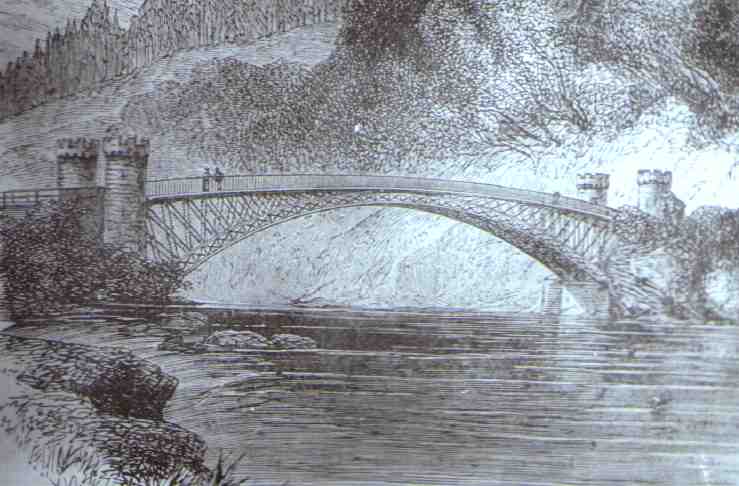
The last named bridge is a remarkably elegant structure thrown over the Spey at a point where the river rushing obliquely against the lofty rock of Craig Ellachie has formed for itself a deep channel not exceeding fifty yards in breadth. Only a few years before there had not been any provision for crossing this river at its lower parts except the very dangerous ferry at Fochabers. The Duke of Gordon had however erected a suspension bridge at that town and the inconvenience was in a great measure removed. Its utility was so generally felt that the demand arose for a second bridge across the river for there was not another by which it could be crossed for a distance of nearly fifty miles up Strath Spey.
It was a difficult stream to span by a bridge at any place in consequence of the violence with which the floods descended at particular seasons. Sometimes even in summer, when not a drop of rain had fallen the flood would come down the Strath in great fury sweeping everything before it this remarkable phenomenon being accounted for by the prevalence of a strong south-westerly wind which blew the loch waters from their beds into the Strath and thus suddenly filled the valley of the Spey. The same phenomenon similarly caused is also frequently observed in the neighbouring river the Findhorn cooped up in its deep rocky bed where the water sometimes comes down in a wave six feet high like a liquid wall sweeping everything before it.
To meet such a contingency it was deemed necessary to provide abundant waterway and to build a bridge offering as little resistance as possible to the passage of the Highland floods. Telford accordingly designed for the passage of the river at Craig Ellachie a light cast-iron arch of 150 feet span with a rise of 20 feet the arch being composed of four ribs each consisting of two concentric arcs forming panels which are filled in with diagonal bars.
The roadway is 15 feet wide and is formed of another arc of greater radius attached to which is the iron railing the spandrels being filled by diagonal ties forming trelliswork. Robert Stephenson took objection to the two dissimilar arches as liable to subject the structure from variations of temperature to very unequal strains. Nevertheless this bridge as well as many others constructed by Telford after a similar plan has stood perfectly well and to this day remains a very serviceable structure.
 Craig-Ellachie Bridge
Its appearance is highly picturesque. The scattered pines and beech
trees on the side of the impending mountain the meadows along the
valley of the Spey and the western approach road to the bridge cut
deeply into the face of the rock combine with the slender
appearance of the iron arch in rendering this spot one of the most
remarkable in Scotland. An iron bridge of a similar span to that
at Craig Ellachie had previously been constructed across the head
of the Dornoch Firth at Bonar near the point where the waters of
the Shin join the sea. The very severe trial which this structure
sustained from the tremendous blow of an irregular mass of fir tree
logs consolidated by ice as well as shortly after from the blow
of a schooner which drifted against it on the opposite side and
had her two masts knocked off by the collision gave him every
confidence in the strength of this form of construction and he
accordingly repeated it in several of his subsequent bridges
though none of them are comparable in beauty with that of Craig Ellachie.
Labours of twenty years
Thus in the course of twenty years 920 miles of capital roads
connected together by no fewer than 1200 bridges were added to the
road communications of the Highlands at an expense defrayed partly
by the localities immediately benefitted and partly by the nation.
The effects of these twenty years' operations were such as follow
the making of roads everywhere development of industry and
increase of civilization. In no districts were the benefits
derived from them more marked than in the remote northern counties
of Sutherland and Caithness. The first stage-coaches that ran
northward from Perth to Inverness were tried in 1806 and became
regularly established in 1811 and by the year 1820 no fewer than
forty arrived at the latter town in the course of every week and
the same number departed from it. Others were established in
various directions throughout the highlands which were rendered as
accessible as any English county.
But not less remarkable were the effects of the road-making upon the industrial habits of the people. Before Telford went into the Highlands they did not know how to work having never been accustomed to labour continuously and systematically. Let our engineer himself describe the moral influences of his Highland contracts "In these works and in the Caledonian Canal about three thousand two hundred men have been annually employed. At first they could scarcely work at all they were totally unacquainted with labour they could not use the tools. They have since become excellent labourers and of the above number we consider about one-fourth left us annually taught to work. These undertakings may indeed be regarded in the light of a working academy from which eight hundred men have annually gone forth improved workmen.
They have either returned to their native districts with the advantage of having used the most perfect sort of tools and utensils (which alone cannot be estimated at less than ten percent on any sort of labour) or they have been usefully distributed through the other parts of the country. Since these roads were made accessible wheelwrights and cartwrights have been established the plough has been introduced and improved tools and utensils are generally used. The plough was not previously employed in the interior and mountainous parts they used crooked sticks with iron on them drawn or pushed along. The moral habits of the great masses of the working classes are changed they see that they may depend on their own exertions for support this goes on silently and is scarcely perceived until apparent by the results. I consider these improvements among the greatest blessings ever conferred on any country. About two hundred thousand pounds has been granted in fifteen years. It has been the means of advancing the country at least a century."
The progress made in the Lowland districts of Scotland since the same period has been no less remarkable. If the state of the country as we have above described it from authentic documents be compared with what it is now it will be found that there are few countries which have accomplished so much within so short a period. It is usual to cite the United States as furnishing the most extraordinary instance of social progress in modem times. But America has had the advantage of importing its civilization for the most part ready made whereas that of Scotland has been entirely her own creation. By nature America is rich and of boundless extent whereas Scotland is by nature poor the greater part of her limited area consisting of sterile heath and mountain. Little more than a century ago Scotland was considerably in the rear of Ireland. It was a country almost without agriculture without mines without fisheries without shipping without money without roads. The people were ill-fed half barbarous and habitually indolent. The colliers and salters were veritable slaves and were subject to be sold together with the estates to which they belonged.
What do we find now? Praedial slavery completely abolished heritable jurisdictions at an end the face of the country entirely changed its agriculture acknowledged to be the first in the world its mines and fisheries productive in the highest degree its banking a model of efficiency and public usefulness its roads equal to the best roads in England or in Europe. The people are active and energetic alike in education in trade in manufactures in construction in invention. Watt's invention of the steam engine and Symington's invention of the steam boat proved a source of wealth and power not only to their own country but to the world at large, while Telford by his roads bound England and Scotland before separated firmly into one and rendered the union a source of wealth and strength to both.
If we look for the causes of this extraordinary social progress we shall probably find the principal to consist in the fact that Scotland though originally poor as a country was rich in Parish schools founded under the provisions of an Act passed by the Scottish Parliament in the year 1696. It was there ordained "that there be a school settled and established and a schoolmaster appointed in every parish not already provided by advice of the heritors and minister of the parish." Common day schools were accordingly provided and maintained throughout the country for the education of children of all ranks and conditions. The consequence was that in the course of a few generations these schools working steadily upon the minds of the young all of whom passed under the hands of the teachers educated the population into a state of intelligence and aptitude greatly in advance of their material well-being, and it is in this circumstance we apprehend that the explanation is to be found of the rapid start forward which the whole country took dating more particularly from the year 1745. Agriculture was naturally the first branch of industry to exhibit signs of decided improvement to be speedily followed by like advances in trade commerce and manufactures. Indeed from that time the country never looked back but her progress went on at a constantly accelerated rate issuing in results as marvellous as they have probably been unprecedented.
The names of Celtic places are highly descriptive. Thus Craig-Ellachie; literally means the rock of separation, Badenoch; bushy or woody, Cairngorm; the blue cairn, Lochinet; the lake of nests, Balknockan; the town of knolls, Dalnasealg; the hunting dale, Alt'n dater; the burn of the horn-blower, and so on.
No sooner were the Highland roads and bridges in full progress than attention was directed to the improvement of the harbours round the coast. Very little had as yet been done for them beyond what nature had effected. Happily there was a public fund at disposal the accumulation of rents and profits derived from the estates forfeited at the rebellion of 1745 which was available for the purpose. The suppression of the rebellion did good in many ways. It broke the feudal spirit which lingered in the Highlands long after it had ceased in every other part of Britain it led to the effectual opening up of the country by a system of good roads and now the accumulated rents of the defeated Jacobite chiefs were about to be applied to the improvement of the Highland harbours for the benefit of the general population.
The harbour of Wick was one of the first to which Telford's attention was directed. Rennie had reported on the subject of its improvement as early as the year 1793 but his plans were not adopted because their execution was beyond the means of the locality at that time. The place had now however become of considerable importance. It was largely frequented by Dutch fishermen during the herring season, and it was hoped that if they could be induced to form a settlement at the place their example might exercise a beneficial influence upon the population.
Mr Telford reported that by the expenditure of about £5890 a capacious and well-protected tidal basin might be formed capable of containing about two hundred herring busses. The Commission adopted his plan and voted the requisite funds for carrying out the works which were begun in 1808. The new station was named Pulteney Town in compliment to Sir William Pulteney the Governor of the Fishery Society, and the harbour was built at a cost of about £12000 of which £8500 was granted from the Forfeited Estates Fund. A handsome stone bridge erected over the River Wick in 1805 after the design of our engineer connect's these improvements with the older town it is formed of three arches having a clear waterway of 156 feet.
The money was well expended as the result proved and Wick is now we believe the greatest fishing station in the world. The place has increased from a little poverty-stricken village to a large and thriving town which swarms during the fishing season with lowland Scotchmen fair Northmen broad-built Dutchmen and kilted Highlanders. The bay is at that time frequented by upwards of a thousand fishing boats and the take of herrings in some years amounts to more than a hundred thousand barrels. The harbour has of late years been considerably improved to meet the growing requirements of the herring trade the principal additions having been carried out in 1823 by Mr Bremner a native engineer of great ability.
Peterhead, Frazerburgh, Banff and other Harbours
Improvements of a similar kind were carried out by the Fishery
Board at other parts of the coast and many snug and convenient
harbours were provided at the principal fishing stations in the
Highlands and Western Islands. Where the local proprietors were
themselves found expending money in carrying out piers and harbours
the Board assisted them with grants to enable the works to be
constructed in the most substantial manner and after the most
approved plans. Thus along that part of the bold northern coast of
the mainland of Scotland which projects into the German Ocean many
old harbours were improved or new ones constructed as at Peterhead
Frazerburgh Banff Cullen Burgh Head and Nairn. At Fortrose
in the Moray Firth at Dingwall in the Cromarty Firth
at Portmaholmac within Tarbet Ness the remarkable headland of the
Firth of Dornoch, at Kirkwall the principal town and place of
resort in the Orkney Islands so well known from Sir Walter Scott's
description of it in the 'Pirate' at Tobermory in the island of
Mull and at other points of the coast piers were erected and
other improvements carried out to suit the convenience of the
growing traffic and trade of the country.
The principal works were those connected with the harbours situated upon the line of coast extending from the harbour of Peterhead in the county of Aberdeen round to the head of the Moray Firth. The shores there are exposed to the full force of the seas rolling in from the Northern Ocean and safe harbours were especially needed for the protection of the shipping passing from north to south. Wrecks had become increasingly frequent and harbours of refuge were loudly called for. At one part of the coast as many as thirty wrecks had occurred within a very short time chiefly for want of shelter.
The situation of Peterhead peculiarly well adapted it for a haven of refuge and the improvement of the port was early regarded as a matter of national importance. Not far from it on the south are the famous Bullars or Boilers of Buchan bold rugged rocks some 200 feet high against which the sea beats with great fury boiling and churning in the deep caves and recesses with which they are perforated. Peterhead stands on the most easterly part of the mainland of Scotland occupying the north-east side of the bay and being connected with the country on the northwest by an isthmus only 800 yards broad. In Cromwell's time the port possessed only twenty tons of boat tonnage and its only harbour was a small basin dug out of the rock. Even down to the close of the sixteenth century the place was but an insignificant fishing village. It is now a town bustling with trade having long been the principal seat of the whale fishery 1500 men of the port being engaged in that pursuit alone and it sends out ships of its own building to all parts of the world its handsome and commodious harbours being accessible at all winds to vessels of almost the largest burden.
Peterhead Harbour
The first works carried out at Peterhead were of a comparatively
limited character the old piers of the south harbour having been
built by Smeaton but improvements proceeded apace with the
enterprise and wealth of the inhabitants. Mr Rennie and after
him Mr Telford fully reported as to the capabilities of the port
and the best means of improving it. Mr Rennie recommended the
deepening of the south harbour and the extension of the jetty of
the west pier at the same time cutting off all projections of rock
from Keith Island on the eastward so as to render the access more
easy. The harbour when thus finished would he estimated give
about 17 feet depth at high water of spring tides.
He also proposed to open a communication across the causeway between the north and south harbours and form a wet dock between them 580 feet long and 225 feet wide the water being kept in by gates at each end. He further proposed to provide an entirely new harbour by constructing two extensive piers for the effectual protection of the northern part of the channel running out one from a rock north of the Green Island about 680 feet long and another from the Roan Head 450 feet long leaving an opening between them of 70 yards. This comprehensive plan unhappily could not be carried out at the time for want of funds but it may be said to have formed the groundwork of all that has been subsequently done for the improvement of the port of Peterhead.
It was resolved in the first place to commence operations by improving the south harbour and protecting it more effectually from south-easterly winds. The bottom of the harbour was accordingly deepened by cutting out 30000 cubic yards of rocky ground and part of Mr Rennie's design was carried out by extending the jetty of the west pier though only for a distance of twenty yards. These works were executed under Mr Telford's directions they were completed by the end of the year 1811 and proved to be of great public convenience.
The trade of the town however so much increased and the port was found of such importance as a place of refuge for vessels frequenting the north seas that in 1816 it was determined to proceed with the formation of a harbour on the northern part of the old channel and the inhabitants having agreed among themselves to contribute to the extent of £10000 towards carrying out the necessary works they applied for the grant of a like sum from the Forfeited Estates Fund which was eventually voted for the purpose. The plan adopted was on a more limited scale than that Proposed by Rennie, but in the same direction and contrived with the same object so that when completed vessels of the largest burden employed in the Greenland fishery might be able to enter one or other of the two harbours and find safe shelter from whatever quarter the wind might blow.
The works were vigorously proceeded with and had made considerable progress when in October 1819 a violent hurricane from the north-east which raged along the coast for several days and inflicted heavy damage on many of the northern harbours destroyed a large part of the unfinished masonry and hurled the heaviest blocks into the sea tossing them about as if they had been pebbles. The finished work had however stood well and the foundations of the piers under low water were ascertained to have remained comparatively uninjured. There was no help for it but to repair the damaged work though it involved a heavy additional cost one-half of which was borne by the Forfeited Estates Fund and the remainder by the inhabitants. Increased strength was also given to the more exposed parts of the pierwork and the slope at the sea side of the breakwater was considerably extended. Those alterations in the design were carried out together with a spacious graving-dock as shown in the preceding plan and they proved completely successful enabling Peterhead to offer an amount of accommodation for shipping of a more effectual kind than was at that time to be met with along the whole eastern coast of Scotland.
Frazerburgh Harbour
The old harbour of Frazerburgh situated on a projecting point of
the coast at the foot of Mount Kennaird about twenty miles north
of Peterhead had become so ruinous that vessels lying within it
received almost as little shelter as if they had been exposed in
the open sea. Mr Rennie had prepared a plan for its improvement
by running out a substantial north-eastern pier and this was
eventually carried out by Mr Telford in a modified form proving
of substantial service to the trade of the port. Since then a
large and commodious new harbour has been formed at the place
partly at the public expense and partly at that of the inhabitants
rendering Frazerburgh a safe retreat for vessels of war as well as
merchantmen.
Banff Harbour
Among the other important harbour works on the northeast coast
carried out by Telford under the Commissioners appointed to
administer the funds of the Forfeited Estates were those at Banff
the execution of which extended over many years, but though
costly they did not prove of anything like the same convenience as
those executed at Peterhead. The old harbour at the end of the
ridge running north and south on which what is called the
'sea town' of Banff is situated was completed in 1775 when the
place was already considered of some importance as a fishing station. This harbour occupies the triangular space at the north-eastern extremity of the projecting point of land at the opposite side of which fronting the north-west is the little town and harbour of Macduff. In 1816 Telford furnished the plan of a new pier and breakwater covering the old entrance which presented an opening to the N.N.E. with a basin occupying the intermediate space. The inhabitants agreed to defray one half of the necessary cost and the Commissioners the other and the plans having been
approved the works were commenced in 1818. They were in full progress when unhappily the same hurricane which in 1819 did so much injury to the works at Peterhead also fell upon those at Banff and carried away a large part of the unfinished pier.
This accident had the effect of interrupting the work as well as increasing its cost but the whole was successfully completed by the year 1822. Although the new harbour did not prove very safe and exhibited a tendency to become silted up with sand it proved of use in many respects more particularly in preventing all swell and agitation in the old harbour which was thereby rendered the safest artificial haven in the Moray Firth. It is unnecessary to specify the alterations and improvements of a similar character adapted to the respective localities which were carried out by our engineer at Burgh Head Nairn Kirkwall Tarbet Tobermory Portmaholmac Dingwall (with its canal two thousand yards long connecting the town in a complete manner with the Firth of Cromarty) Cullen Fortrose Ballintraed Portree Jura Gourdon Invergordon and other places. Down to the year 1823 the Commissioners had expended £108,530 on the improvements of these several ports in aid of the local contributions of the inhabitants and adjoining proprietors to a considerably greater extent the result of which was a great increase in the shipping accommodation of the coast towns to the benefit of the local population and of ship-owners and navigators generally.
Telford's principal harbour works in Scotland were those of Aberdeen and Dundee which next to Leith (the port of Edinburgh) formed the principal havens along the east coast. The neighbourhood of Aberdeen was originally so wild and barren that Telford expressed his surprise that any class of men should ever have settled there. An immense shoulder of the Grampian mountains extends down to the sea-coast where it terminates in a bold rude promontory. The country on either side of the Dee which flows past the town was originally covered with many granite blocks, one called Craig Metellan lay right in the river's mouth and formed with the sand an almost effectual bar to its navigation. Although in ancient times a little cultivatable land lay immediately outside the town, the region beyond was as sterile as is possible for land to be.
"Any wher" says an ancient writer "after yow pass a myll without the tonne the countrey is barren lyke the hills craigy, the plaines full of marishes and mosses the feilds are covered with heather or peeble stons, then come feilds mixt with thes bot few. The air is temperat and healthful about it and it may be that the citizens owe the acuteness of their wits thereunto and their civill inclinations, the lyke not easie to be found under northerlie climats damped for the most pairt with air of a grosse consistence." The old inhabitants of Aberdeen and its neighbourhood were really as rough as their soil. Judged by their records they must have been dreadfully haunted by witches and sorcerers down to a comparatively recent period, witch-burning having been common in the town until the end of the sixteenth century. We find that in one year no fewer than twenty-three women and one man were burnt the Dean of Guild Records containing the detailed accounts of the "loads of peattis tar barrellis", and other combustibles used in burning them.
The lairds of the Garioch, a district in the neighbourhood seem to have been still more terrible than the witches being accustomed to enter the place and make an onslaught upon the citizens according as local rage and thirst for spoil might incline them. On one of such occasions eighty of the inhabitants were killed or wounded. Down even to the middle of last century the Aberdonian notions of personal liberty seem to have been very restricted for between 1740 and 1746 we find that people were kidnapped, put on board ships and despatched to the American plantations where they were sold as slaves. Strangest of all the men who carried on this slave trade were local dignitaries one of them being a town's baillie another the town clerk depute.
Those kidnapped were openly "driven in flocks through the town like herds of sheep under the care of a keeper armed with a whip." So open was the traffic that the public workhouse was used for their reception until the ships sailed and when that was filled the tolbooth or common prison was made use of. The vessels which sailed from the harbour for America in 1743 contained no fewer than sixty-nine persons and it is supposed that in the six years during which the Aberdeen slave trade was at its height about six hundred were transported for sale very few of whom ever returned. This slave traffic was doubtless stimulated by the foreign ships beginning to frequent the port for the inhabitants were industrious and their plaiding linen and worsted stockings were in much request as articles of merchandise.
One of the Aberdonians shipped out returned Peter Williamson a native of the town sold for a slave in Pennsylvania "a rough ragged humle-headed long stowie clever boy" who reaching York published an account of the infamous slave traffic in a pamphlet which excited extraordinary interest at the time and met with a rapid and extensive circulation. But his exposure of kidnapping gave very great offence to the magistrates who dragged him before their tribunal as having "published a scurrilous and infamous libel on the corporation" and he was sentenced to be imprisoned until he should sign a denial of the truth of his statements. He brought an action against the corporation for their proceedings and obtained a verdict and damages, and he further proceeded against Baillie Fordyce (one of his kidnappers and others from whom he obtained 200L. damages with costs. The system was thus effectually put a stop to.
Cured salmon were also exported in large quantities. As early as 1659 a quay was formed along the Dee towards the village of Foot Dee. "Beyond Futty" says an old writer "lyes the fisher boat heavne, and after that towards the promontorie called Sandenesse ther is to be seen a grosse bulk of a building vaulted and flatted above (the Blockhous they call it) begun to be builded anno 1513 for guarding the entree of the harboree from pirats and algarads, and cannon wer planted ther for that purpose or at least that from thence the motions of pirats might be tymouslie foreseen. This rough piece of work was finished anno 1542 in which yer lykewayes the mouth of the river Dee was locked with cheans of iron and masts of ships crossing the river not to be opened bot at the citizens' pleasure."
After the Union but more especially after the rebellion of 1745 the trade of Aberdeen made considerable progress. Although Burns in 1787 described the place as a "lazy toun" the inhabitants were displaying much energy in carrying out improvements in their port. In 1775 the foundation stone of the new pier designed by Smeaton was laid with great ceremony and the works proceeding to completion, a new pier twelve hundred feet long terminating in a round head was finished under six years. The trade of the place was however as yet too small to justify anything beyond a tidal harbour and the engineer's views were limited to that object. He found the river meandering over an irregular space about five hundred yards in breadth, and he applied the only practicable remedy by confining the channel as much as the limited means placed at his disposal enabled him to do and directing the land floods so as to act upon and diminish the bar. Opposite the north pier on the south side of the river, Smeaton constructed a breast-wall about half the length of the pier. Owing however to a departure from that engineer's plans by which the pier was placed too far to the north it was found that a heavy swell entered the harbour and to obviate this formidable inconvenience a bulwark was projected from it so as to occupy about one third of the channel entrance.
The trade of the place continuing to increase Rennie was called upon in 1797 to examine and report upon the best means of improving the harbour when he recommended the construction of floating docks upon the sandy flats called Foot Dee. Nothing was done at the time as the scheme was very costly and considered beyond the available means of the locality. But the magistrates kept the subject in mind and when Telford made his report on the best means of improving the harbour in 1801 he intimated that the inhabitants were ready to cooperate with the Government in rendering it capable of accommodating ships of war as far as their circumstances would permit.
In 1807 the south pier head built by Smeaton was destroyed by a storm and the time had arrived when something must be done not only to improve but even to preserve the port. The magistrates accordingly proceeded in 1809 to rebuild the pier head out of cut granite and at the same time they applied to Parliament for authority to carry out further improvements after the plan recommended by Telford and the necessary powers were conferred in the following year. The new works comprehended a large extension of the wharfage accommodation the construction of floating and graving docks increased means of scouring the harbour and ensuring greater depth of water on the bar across the river's mouth and the provision of a navigable communication between the Aberdeenshire Canal and the new harbour.
The extension of the north pier was first proceeded with under the superintendence of John Gibb the resident engineer and by the year 1811 the whole length of 300 additional feet had been completed. The beneficial effects of this extension were so apparent that a general wish was expressed that it should be carried further and it was eventually determined to extend the pier 780 feet beyond Smeaton's head by which not only was much deeper water secured but vessels were better enabled to clear the Girdleness Point. This extension was successfully carried out by the end of the year 1812. A strong breakwater about 800 feet long was also run out from the south shore leaving a space of about 250 feet as an entrance thereby giving greater protection to the shipping in the harbour while the contraction of the channel by increasing the "scour" tended to give a much greater depth of water on the bar.
The outer head of the pier was seriously injured by the heavy storms of the two succeeding winters which rendered it necessary to alter its formation to a very flat slope of about five to one all round the head. New wharves were at the same time constructed inside the harbour a new channel for the river was excavated which further enlarged the floating space and wharf accommodation wet and dry docks were added until at length the quay berthage amounted to not less than 6290 feet or nearly a mile and a quarter in length. By these combined improvements an additional extent of quay room was obtained of about 4000 feet an excellent tidal harbour was formed in which at spring tides the depth of water is about 15 feet while on the bar it was increased to about 19 feet. The prosperity of Aberdeen had meanwhile been advancing apace. The city had been greatly beautified and enlarged shipbuilding had made rapid progress Aberdeen clippers became famous and Aberdeen merchants carried on a trade with all parts of the world manufactures of wool cotton flax and iron were carried on with great success its population rapidly increased and as a maritime city Aberdeen took rank as the third in Scotland the tonnage entering the port having increased from 50,000 tons in 1800 to about 300,000 in 1860.
Improvements of an equally important character were carried out by Telford in the port of Dundee also situated on the east coast of Scotland at the entrance to the Firth of Tay. There are those still living at the place who remember its former haven consisting of a crooked wall affording shelter to only a few fishing boats or smuggling vessels its trade being then altogether paltry scarcely deserving the name and its population not one fifth of what it now is. Helped by its commodious and capacious harbour it has become one of the most populous and thriving towns on the east coast.
Dundee Harbour
The trade of the place took a great start forward at the close of
the war and Telford was called upon to supply the plans of a
new harbour. His first design which he submitted in 1814 was of
a comparatively limited character, but it was greatly enlarged
during the progress of the works. Floating docks were added as
well as graving docks for large vessels. The necessary powers were
obtained in 1815 the works proceeded vigorously under the Harbour
Commissioners who superseded the old obstructive corporation, and
in 1825 the splendid new floating dock 750 feet long by 450 broad
having an entrance lock of 170 feet long and 40 feet wide was opened
to the shipping of all countries.
 Caledonian Canal
The formation of a navigable highway through the chain of locks
lying in the Great Glen of the Highlands and extending diagonally
across Scotland from the Atlantic to the North Sea had long been
regarded as a work of national importance. As early as 1773
James Watt then following the business of a land surveyor at Glasgow
made a survey of the country at the instance of the Commissioners
of Forfeited Estates. He pronounced the canal practicable and
pointed out how it could best be constructed. There was certainly
no want of water for Watt was repeatedly drenched with rain while
he was making his survey and he had difficulty in preserving even
his journal book. "On my way home I passed through the
wildest country I ever saw and over the worst conducted roads."
Twenty years later in 1793 Mr Rennie was consulted as to the
canal and he also prepared a scheme but nothing was done. The
project was however revived in 1801 during the war with Napoleon
when various inland ship canals such as those from London to
Portsmouth and from Bristol to the English Channel were under
consideration with the view of enabling British shipping to pass
from one part of the kingdom to another without being exposed to
the attacks of French privateers. But there was another reason for
urging the formation of the canal through the Great Glen of Scotland
which was regarded as of considerable importance before the
introduction of steam enabled vessels to set the winds and tides at
comparative defiance.
It was this vessels sailing from the eastern ports to America had to beat up the Pentland Firth often against adverse winds and stormy seas which rendered the navigation both tedious and dangerous. Thus it was cited by Sir Edward Parry in his evidence before Parliament in favour of completing the Caledonian Canal that of two vessels despatched from Newcastle on the same day one bound for Liverpool by the north of Scotland and the other for Bombay by the English Channel and the Cape of Good Hope the latter reached its destination first! Another case may be mentioned that of an Inverness vessel which sailed for Liverpool on a Christmas Day reached Stromness Harbour in Orkney on the 1st of January and lay there windbound with a fleet of other traders until the middle of April following! In fact the Pentland Firth which is the throat connecting the Atlantic and German Oceans through which the former rolls its long majestic waves with tremendous force was long the dread of mariners and it was considered an object of national importance to mitigate the dangers of the passage towards the western Seas.
As the lochs occupying the chief part of the bottom of the Great Glen were of sufficient depth to be navigable by large vessels it was thought that if they could be connected by a ship canal so as to render the line of navigation continuous it would be used by shipping to a large extent and prove of great public service. Five hundred miles of dangerous navigation by the Orkneys and Cape Wrath would thereby be saved while ships of war were this track open to them might reach the north of Ireland in two days from Fort George near Inverness. When the scheme of the proposed canal was revived in 1801 Telford was requested to make a survey and send in his report on the subject. He immediately wrote to his friend James Watt saying "I have so long accustomed myself to look with a degree of reverence at your work that I am particularly anxious to learn what occurred to you in this business while the whole was fresh in your mind".
"The object appears to me so great and so desirable that I am convinced you will feel a pleasure in bringing it again under investigation and I am very desirous that the thing should be fully and fairly explained so that the public may be made aware of its extensive utility. If I can accomplish this I shall have done my duty and if the project is not executed now some future period will see it done and I shall have the satisfaction of having followed you and promoted its success." We may here state that Telford's survey agreed with Watt's in the most important particulars and that he largely cited Watt's descriptions of the proposed scheme in his own report.
Telford's first inspection of the district was made in 1801 and his report was sent in to the Treasury in the course of the following year. Lord Bexley then Secretary to the Treasury took a warm personal interest in the project and lost no opportunity of actively promoting it. A board of commissioners was eventually appointed to carry out the formation of the canal. Telford on being appointed principal engineer of the undertaking was requested at once to proceed to Scotland and prepare the necessary working survey. He was accompanied on the occasion by Mr Jessop as consulting engineer. Twenty thousand pounds were granted and the works were commenced in the beginning of 1804 by the formation of a dock or basin adjoining the intended tide lock at Corpach near Bannavie.
The basin at Corpach formed the southernmost point of the intended canal. It is situated at the head of Loch Eil amidst some of the grandest scenery of the Highlands. Across the Loch is the little town of Fort William one of the forts established at the end of the seventeenth century to keep the wild Highlanders in subjection. Above it rise hills over hills of all forms and sizes and of all hues from grass-green below to heather-brown and purple above capped with heights of weather-beaten grey, while towering over all stands the rugged mass of Ben Nevis a mountain almost unsurpassed for picturesque grandeur. Along the western foot of the range which extends for some six or eight miles lies a long extent of brown bog on the verge of which by the river Lochy stand the ruins of Inverlochy Castle.
The works at Corpach involved great labour and extended over a long series of years. The difference between the level of Loch Eil and Loch Lochy is ninety feet while the distance between them was less than eight miles. It was therefore necessary to climb up the side of the hill by a flight of eight gigantic locks clustered together and which Telford named "Neptune's Staircase". The ground passed over was in some places very difficult requiring large masses of embankment the slips of which in the course of the work frequently occasioned serious embarrassment. The basin on Loch Eil on the other hand was constructed amidst rock and considerable difficulty was experienced in getting in the necessary coffer-dam for the construction of the opening into the sea-lock the entrance-sill of which was laid upon the rock itself so that there was a depth of 21 feet of water upon it at high water of neap tides.
At the same time that the works at Corpach were begun the dock or basin at the north-eastern extremity of the canal situated at Clachnaharry on the shore of Loch Beauly was also laid out and the excavations and embankments were carried on with considerable activity. This dock was constructed about 967 yards long and upwards of 162 yards in breadth giving an area of about 32 acres --forming in fact a harbour for the vessels using the canal. The dimensions of the artificial waterway were of unusual size as the intention was to adapt it throughout for the passage of a 32-gun frigate of that day fully equipped and laden with stores. The canal as originally resolved upon was designed to be 110 feet wide at the surface and 50 feet at the bottom with a depth in the middle of 20 feet, though these dimensions were somewhat modified in the execution of the work. The locks were of corresponding large dimensions each being from 170 to 180 feet long 40 broad and 20 deep.
 Lock Caledonian Canal
Between these two extremities of the canal, Corpach on the
south-west and Clachnaharry on the north-east, extends the chain of
freshwater lochs, Loch Lochy on the south, next Loch Oich, then
Loch Ness, and lastly furthest north, the small Loch of Dochfour.
The whole length of the navigation is 60 miles 40 chains of which
the navigable lochs constitute about 40 miles leaving only about
20 miles of canal to be constructed but of unusually large
dimensions and through a very difficult country.
The summit loch of the whole is Loch Oich the surface of which is exactly a hundred feet above high water mark both at Inverness and Fort William, and to this sheet of water the navigation climbs up by a series of locks from both the eastern and western seas. The whole number of these is twenty-eight: the entrance-lock at Clachnaharry constructed on piles at the end of huge embankments forced out into deep water at Loch Beady, another at the entrance to the capacious artificial harbour above mentioned at Muirtown, four connected locks at the southern end of this basin, a regulating lock a little to the north of Loch Dochfour, five contiguous locks at Fort Augustus at the south end of Loch Ness, another called the Kytra Lock about midway between Fort Angustus and Loch Oich, a regulating lock at the north-east end of Loch Oich, two contiguous locks between Lochs Oich and Lochy, a regulating lock at the south-west end of Loch Lochy, next the grand series of locks, eight in number called "Neptune's Staircase", at Bannavie within a mile and a quarter of the sea, two locks descending to Corpach basin, and lastly the great entrance or sea-lock at Corpach.
The northern entrance lock from the sea at Loch Beauly is at Clachnaharry near Inverness. The works here were not accomplished without much difficulty as well as labour partly from the very gradual declivity of the shore and partly from the necessity of placing the sea lock on absolute mud which afforded no foundation other than what was created by compression and pile-driving. The mud was forced down by throwing upon it an immense load of earth and stones which was left during twelve months to settle; after which a shaft was sunk to a solid foundation and the masonry of the sea-lock was then founded and built therein.
In the 'Sixteenth Report of the Commissioners of the Caledonian Canal' the following reference is made to this important work which was finished in 1812,"The depth of the mud on which it may be said to be artificially seated is not less than 60 feet; so that it cannot be deemed superfluous at the end of seven years to state that no subsidence is discoverable; and we presume that the entire lock as well as every part of it may now be deemed as immovable and as little liable to destruction as any other large mass of masonry. This was the most remarkable work performed under the immediate care of Mr Matthew Davidson our superintendent at Clachnaharry from 1804 till the time of his decease. He was a man perfectly qualified for the employment by inflexible integrity unwearied industry and zeal to a degree of anxiety in all the operations committed to his care."
As may naturally be supposed the execution of these great works involved vast labour and anxiety. They were designed with much skill and executed with equal ability. There were lock gates to be constructed principally of cast iron sheathed with pine planking. Eight public road bridges crossed the line of the canal which were made of cast iron and swung horizontally. There were many mountain streams swollen to torrents in winter crossing under the canal for which abundant water-way had to be provided involving the construction of numerous culverts tunnels and under-bridges of large dimensions. There were also powerful sluices to let off the excess of water sent down from the adjacent mountains into the canal during winter. Three of these of great size high above the river Lochy are constructed at a point where the canal is cut through the solid rock; and the sight of the mass of waters rushing down into the valley beneath gives an impression of power which once seen is never forgotten.
These great works were only brought to a completion after the labours of many years during which the difficulties encountered in their construction had swelled the cost of the canal far beyond the original estimate. The rapid advances which had taken place in the interval in the prices of labour and materials also tended greatly to increase the expenses and after all the canal when completed and opened was comparatively little used. This was doubtless owing in a great measure to the rapid changes which occurred in the system of navigation shortly after the projection of the undertaking. For these Telford was not responsible. He was called upon to make the canal and he did so in the best manner. Engineers are not required to speculate as to the commercial value of the works they are required to construct; and there were circumstances connected with the scheme of the Caledonian Canal which removed it from the category of mere commercial adventures. It was a Government project and it proved a failure as a paying concern. Hence it formed a prominent topic for discussion in the journals of the day; but the attacks made upon the Government because of their expenditure on the hapless undertaking were perhaps more felt by Telford who was its engineer than by all the ministers of state conjoined.
"The unfortunate issue of this great work" writes the present engineer of the canal, "was a grievous disappointment to Telford and was in fact the one great bitter in his otherwise unalloyed cup of happiness and prosperity. The undertaking was maligned by thousands who knew nothing of its character. It became 'a dog with a bad name' and all the proverbial consequences followed. The most absurd errors and misconceptions were propagated respecting it from year to year and it was impossible during Telford's lifetime to stem the torrent of popular prejudice and objurgation. It must however be admitted after a long experience that Telford was greatly over-sanguine in his expectations as to the national uses of the canal and he was doomed to suffer acutely in his personal feelings little though he may have been personally to blame the consequences of what in this commercial country is regarded as so much worse than a crime namely a financial mistake."
Telford's great sensitiveness made him feel the ill success of this enterprise far more than most other men would have done. He was accustomed to throwing himself into the projects on which he was employed with an enthusiasm almost poetic. He regarded them not merely as so much engineering but as works which were to be instrumental in opening up the communications of the country and extending its civilization. Viewed in this light his canals roads bridges and harbours were unquestionably of great national importance though their commercial results might not in all cases justify the estimates of their projectors. To refer to like instances--no one can doubt the immense value and public uses of Mr Rennie's Waterloo Bridge or Mr Robert Stephenson's Britannia and Victoria Bridges though every one knows that commercially they have been failures. But it is probable that neither of these eminent engineers gave himself anything like the anxious concern that Telford did about the financial issue of his undertaking. Were railway engineers to fret and vex themselves about the commercial value of the schemes in which they have been engaged there are few of them but would be so haunted by the ghosts of wrecked speculations that they could scarcely lay their heads upon their pillows for a single night in peace.
While the Caledonian Canal was in progress Telford was occupied in various works of a similar kind in England and Scotland and also upon one in Sweden. In 1804 while on one of his journeys to the north he was requested by the Earl of Eglinton and others to examine a project for making a canal from Glasgow to Saltcoats and Ardrossan on the north-western coast of the county of Ayr passing near the important manufacturing town of Paisley. A new survey of the line was made and the works were carried on during several successive years until a very fine capacious canal was completed on the same level as far as Paisley and Johnston.
But the funds of the company falling short the works were stopped and the canal was carried no further. Besides the measures adopted by the Clyde Trustees to deepen the bed of that river and enable ships of large burden to pass up as high as Glasgow had proved so successful that the ultimate extension of the canal to Ardrossan was no longer deemed necessary and the prosecution of the work was accordingly abandoned. But as Telford has observed no person suspected when the canal was laid out in 1805 "that steamboats would not only monopolise the trade of the Clyde but penetrate into every creek where there is water to float them in the British Isles and the continent of Europe and be seen in every quarter of the world."
Another of the navigations on which Telford was long employed was that of the river Weaver in Cheshire. It was only twenty-four miles in extent but of considerable importance to the country through which it passed accommodating the salt-manufacturing districts of which the towns of Nantwich Northwich and Frodsham are the centres. The channel of the river was extremely crooked and much obstructed by shoals when Telford took the navigation in hand in the year 1807 and a number of essential improvements were made in it by means of new locks weirs and side cuts which had the effect of greatly improving the communications of these important districts.
In the following year we find our engineer consulted at the instance of the King of Sweden on the best mode of constructing the Gotha Canal between Lake Wenern and the Baltic to complete the communication with the North Sea. In 1808 at the invitation of Count Platen, Telford visited Sweden and made a careful survey of the district. The service occupied him and his assistants two months after which he prepared and sent in a series of detailed plans and sections together with an elaborate report on the subject. His plans having been adopted he again visited Sweden in 1810 to inspect the excavations which had already been begun when he supplied the drawings for the locks and bridges. With the sanction of the British Government he at the same time furnished the Swedish contractors with patterns of the most improved tools used in canal making and took with him a number of experienced lock makers and navvies for the purpose of instructing the native workmen.
The construction of the Gotha Canal was an undertaking of great magnitude and difficulty similar in many respects to the Caledonian Canal though much more extensive. The length of artificial canal was 55 miles and of the whole navigation including the lakes 120 miles. The locks are 120 feet long and 24 feet broad; the width of the canal at bottom being 42 feet and the depth of water 10 feet. The results so far as the engineer was concerned were much more satisfactory than in the case of the Caledonian Canal. While in the one case he had much obloquy to suffer for the services he had given in the other he was honoured and feted as a public benefactor the King conferring upon him the Swedish order of knighthood and presenting him with his portrait set in diamonds.
Among the various canals throughout England which Telford was employed to construct or improve down to the commencement of the railway era were the Gloucester and Berkeley Canal in 1818; the Grand Trunk Canal in 1822; the Harecastle Tunnel which he constructed anew in 1824-7, the Birmingham Canal in 1824; and the Macclesfield and Birmingham and Liverpool Junction Canals in 1825. The Gloucester and Berkeley Canal Company had been unable to finish their works begun some thirty years before; but with the assistance of a loan of 160000L. from the Exchequer Bill Loan Commissioners they were enabled to proceed with the completion of their undertaking. A capacious canal was cut from Gloucester to Sharpness Point about eight miles down the Severn which had the effect of greatly improving the convenience of the port of Gloucester; and by means of this navigation ships of large burden can now avoid the circuitous and difficult passage of the higher part of the river very much to the advantage of the trade of the place.
The formation of a new tunnel through Harecastle Hill for the better accommodation of the boats passing along the Grand Trunk Canal was a formidable work. The original tunnel it will be remembered, was laid out by Brindley about fifty years before and occupied eleven years in construction. But the engineering appliances of those early days were very limited, the pumping powers of the steam engine had not been fairly developed and workmen were as yet only half-educated in the expert use of tools. The tunnel no doubt answered the purpose for which it was originally intended, but it was very soon found too limited for the traffic passing along the navigation. It was little larger than a sewer and admitted the passage of only one narrow boat seven feet wide at a time, involving very heavy labour on the part of the men who worked it through.
This was performed by what was called legging. The 'leggers' lay upon the deck of the vessel or upon a board slightly projecting from either side of it and by thrusting their feet against the slimy roof or sides of the tunnel, walking horizontally as it were, they contrived to push it through. But it was no better than horsework, and after 'legging' Harecastle Tunnel which is more than a mile and a half long, the men were usually completely exhausted and as wet from perspiration as if they had been dragged through the canal itself. The process occupied about two hours and by the time the passage of the tunnel was made there was usually a collection of boats at the other end waiting their turn to pass. Thus much contention and confusion took place amongst the boatmen, who were a very rough class of labourers and many furious battles were fought by the claimants for the first turn 'through.'
Regulations were found of no avail to settle these disputes, still less to accommodate the large traffic which continued to keep flowing along the line of the Grand Trunk and steadily increased with the advancing trade and manufactures of the country. Loud complaints were made by the public but they were disregarded for many years, and it was not until the proprietors were threatened with rival canals and railroads that they determined on, what they could no longer avoid if they desired to retain the carrying trade of the district, the enlargement of the Harecastle Tunnel. Telford was requested to advise the Company what course was most proper to be adopted in the matter, and after examining the place he recommended that an entirely new tunnel should be constructed nearly parallel with the old one, but of much larger dimensions.
The work was begun in 1824 and completed in 1827 in less than three years. There were at that time throughout the country plenty of skilled labourers and contractors, many of them trained by their experience upon Telford's own works, whereas Brindley had in a great measure to make his workmen out of the rawest material. Telford also had the advantage of greatly improved machinery and an abundant supply of money, the Grand Trunk Canal Company having become prosperous and rich paying large dividends. It is therefore meet while eulogising the despatch with which he was enabled to carry out the work, to point out that the much greater period occupied in the earlier undertaking is not to be set down to the disparagement of Brindley who had difficulties to encounter which the later engineer knew nothing of.
The length of the new tunnel is 2,926 yards, it is 16 feet high and 14 feet broad, 4 feet 9 inches of the breadth being occupied by the towing-path, for 'legging' was now dispensed with and horses hauled along the boats instead of their being thrust through by men. The tunnel is in so perfectly straight a line that its whole length can be seen through at one view, and though it was constructed by means of fifteen different pitshafts sunk to the same line along the length of the tunnel, the workmanship is so perfect that the joinings of the various lengths of brickwork are scarcely discernible. The convenience afforded by the new tunnel was very great and Telford mentions that on surveying it in 1829 he asked a boatman coming out of it how he liked it? "I only wish that it reached all the way to Manchester!" was answered.
Harecastle Tunnel
At the time that Telford was engaged upon the tunnel at
Harecastle he was employed to improve and widen the Birmingham
Canal, another of Brindley's works. Though the accommodation
provided by it had been sufficient for the traffic when originally
constructed, the expansion of the trade of Birmingham and the
neighbourhood accelerated by the formation of the canal itself
had been such as completely to outgrow its limited convenience and
capacity and its enlargement and improvement now became absolutely
necessary. Brindley's Canal for the sake of cheapness of
construction, money being much scarcer and more difficult to be
raised in the early days of canals, was also winding and crooked,
and it was considered desirable to shorten and straighten it by
cutting off the bends at different places. At the point at which
the canal entered Birmingham it had become "little better than a
crooked ditch with scarcely the appearance of a towing-path the
horses frequently sliding and staggering in the water, the
hauling-lines sweeping the gravel into the canal, and the
entanglement at the meeting of boats being incessant, whilst at the
locks at each end of the short summit at Smethwick crowds of
boatmen were always quarrelling or offering premiums for a
preference of passage, and the mine-owners injured by the delay
were loud in their just complaints."
Telford proposed an effective measure of improvement which was taken in hand without loss of time and carried out greatly to the advantage of the trade of the district. The numerous bends in the canal were cut off, the water-way was greatly widened, the summit at Smethwick was cut down to the level on either side and a straight canal forty feet wide without a lock was thus formed as far as Bilston and Wolverhampton, while the length of the main line between Birmingham and Autherley along the whole extent of the 'Black country' was reduced from twenty-two to fourteen miles. At the same time the obsolete curvatures in Brindley's old canal were converted into separate branches or basins for the accommodation of the numerous mines and manufactories on either side of the main line.
In consequence of the alterations which had been made in the canal it was found necessary to construct numerous large bridges. One of these, a cast iron bridge at Galton of 150 feet span, has been much admired for its elegance lightness and economy of material. Several others of cast iron were constructed at different points and at one place the canal itself is carried along on an aqueduct of the same material as at Pont-Cysylltau. The whole of these extensive improvements were carried out in the short space of two years and the result was highly satisfactory "proving that where business is extensive liberal expenditure of this kind is true economy."
Galton Bridge - Birmingham Canal
In 1825 Telford was called upon to lay out a canal to connect
the Grand Trunk at the north end of Harecastle Tunnel with the
rapidly improving towns of Congleton and Macclesfield. The line
was twenty-nine miles in length, ten miles on one level from
Harecastle to beyond Congleton, then ascending 114 feet by eleven
locks it proceeded for five miles on a level past Macclesfield
and onward to join the Peak Forest Canal at Marple. The navigation
was thus conducted upon two levels, each of considerable length,
and it so happened that the trade of each was in a measure
distinct and required separate accommodation.
The traffic of the whole of the Congleton district had ready access to the Grand Trunk system without the labour expense and delay involved by passing the boats through locks, while the coals brought to Macclesfield to supply the mills were carried throughout upon the upper level also without lockage. The engineer's arrangement proved highly judicious and furnishes an illustration of the tact and judgment which he usually displayed in laying out his works for practical uses. Telford largely employed cast iron in the construction of this canal using it in the locks and gates as well as in an extensive aqueduct which it was necessary to construct over a deep ravine after the plan pursued by him at Pont-Cysylltau and other places.
The last canal constructed by Telford was the Birmingham and Liverpool Junction extending from the Birmingham Canal near Wolverhampton in nearly a direct line by Market Drayton, Nantwich, and through the city of Chester by the Ellesmere Canal to Ellesmere Port on the Mersey. The proprietors of canals were becoming alarmed at the numerous railways projected through the districts heretofore served by their water-ways, and among other projects one was set on foot as early as 1825 for constructing a line of railway from London to Liverpool. Telford was consulted as to the best means of protecting existing investments and his advice was to render the canal system as complete as it could be made, for he entertained the conviction which has been justified by experience that such navigations possessed peculiar advantages for the conveyance of heavy goods and that if the interruptions presented by locks could be done away with or materially reduced, a large portion of the trade of the country must continue to be carried by the water roads. The new line recommended by him was approved and adopted and the works were commenced in 1826. A second complete route was thus opened up between Birmingham and Liverpool and Manchester by which the distance was shortened twelve miles and the delay occasioned by 320 feet of upward and downward lockage was done away with.
Telford was justly proud of his canals which were the finest works of their kind that had yet been executed in England. Capacious, convenient and substantial they embodied his most ingenious contrivances and his highest engineering skill. Hence we find him writing to a friend at Langholm that so soon as he could find "sufficient leisure from his various avocations in his own unrivalled and beloved island" it was his intention to visit France and Italy for the purpose of ascertaining what foreigners had been able to accomplish compared with ourselves in the construction of canals, bridges, and harbours. "I have no doubt as to their inferiority. During the war, just brought to a close, England has not only been able to guard her own head and to carry on a gigantic struggle but at the same time to construct canals, roads, harbours, bridges, magnificent works of peace, the like of which are probably not to be found in the world. Are not these things worthy of a nation's pride?"
The misfortunes of the Caledonian Canal did not end with the life of Telford. The first vessel passed through it from sea to sea in October 1822 by which time it had cost about £1,000,000 sterling or double the original estimate. Notwithstanding this large outlay it appears that the canal was opened before the works had been properly completed, and the consequence was that they very shortly fell into decay. It even began to be considered whether the canal ought not to be abandoned. In 1838 James Walker C.E. an engineer of the highest eminence examined it and reported fully on its then state, strongly recommending its completion as well as its improvement. His advice was eventually adopted and the canal was finished accordingly at an additional cost of about £200,000 and the whole line was re-opened in 1847, since which time it has continued in useful operation. The passage from sea to sea at all times can now be depended on and it can usually be made in forty-eight hours. As the trade of the North increases the uses of the canal will probably become much more decided than they have heretofore proved.